Crafting Futures: Making climate change tangible and initiating urban transformation
| Trade & Logistics | Learning & Education | Mobility | Environment & Energy | Data Management & Analysis | Human-Machine Interaction | Sensors & Networks | Virtual & Augmented Reality | Smart Data & Knowledge Services | Kaiserslautern | Press release

 © Carl-Zeiss-Stiftung
Floods, heat waves, traffic gridlock: the way cities are designed and the way we use them in our daily lives contributes to a multitude of such massive, and in their sum significantly harmful, consequences of climate change and various urban functional systems. There is sufficient scientific research available on how cities need to be transformed to remain livable or even habitable in the future. The reconstruction and the resulting changes in everyday behaviour could significantly contribute to reducing the causes and consequences of climate change.
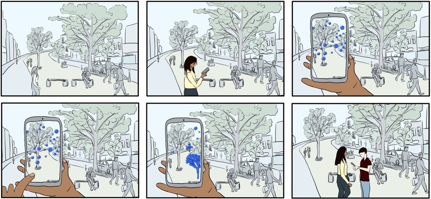
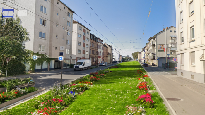
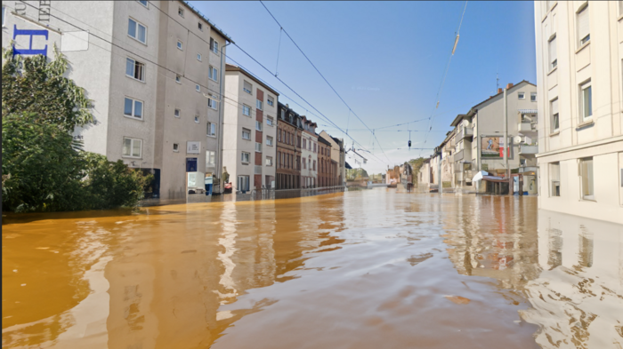
It is well known that people are particularly quick to take action when they can directly see and feel the effects. ‘But as long as the causes, consequences and interactions are only available in theory, action will not be taken,’ explains Prof. Dr. Till Nagel, project manager at the Human Data Interaction Lab at Mannheim University of Applied Sciences. ’The CO₂ emissions from fossil-fuel-based mobility are well known, but cannot be seen or grasped, and urban heat islands have been experienced sporadically in recent years, but existing forecasts for 2040 remain theoretical. But what if you could actually see the CO₂ masses of circulating cars, the current and future overheating, the possible flooding from heavy rain in your familiar street space – and that in any place in the city?’

‘Citizens can use their own smartphone, tablet or even data glasses to choose topics such as heat, heavy rain or emissions. In addition, AR technologies and the intelligent aggregation and analysis of urban actual and future data offer a new experience and provide a deep understanding of very relevant but previously invisible interrelationships.’
The system also allows users to explore future scenarios interactively: ‘Our goal is to enable people to make urban planning changes by simply drawing them directly onto the environment. A generative AI realistically integrates these into the existing landscape so that their effects on CO₂ emissions, temperature and other factors can be immediately understood and experienced in the data visualisation,’ explains Dr Martin Berchtold, Professor of Digitalisation, Visualisation and Monitoring in Spatial Planning at RPTU. Crafting Futures thus creates a highly interdisciplinary link between scientific knowledge, mathematical modelling and urban planning problem-solving strategies.
 © Hochschule Mannheim
Project components Mannheim University of Applied Sciences
Within the framework of the project, the HDIL will play a major role in the development and implementation of the AR-based visualisations. The approach is based on situated visualisations that embed data context-sensitively into physical space. After designing the first prototypes, user-friendly and high-performance visualisations will be developed that will be evaluated in terms of understanding and acceptance both in the laboratory and in real urban environments.
Project components RPTU
In the project, RPTU will combine urban planning expertise with the integrated application of digital data, tools and methods. For Crafting Futures, Professor Martin Berchtold and his research group will address the fundamental development of scenarios in the context of urban public spaces and explore how these can be virtually presented in such a way that the visualisations can be intuitively grasped by users.
Project shares DFKI
The SmartCity Living Lab (SCLL) at DFKI is developing robust and specialised systems for the management, processing and analysis of urban data, as well as models for the high-performance calculation of future scenarios. Furthermore, generative AI methods are provided to generate realistic representations in urban space.
 © Google Street View/DFKI
 © Google Street View/DFKI
About the Human Data Interaction Lab
The Human Data Interaction Lab (HDIL) at Mannheim University of Applied Sciences is exploring new ways of supporting different user groups at the interface between human-centred design and data-driven analysis. The main areas of research are aesthetic and everyday visualisation, interaction design and usability, as well as data literacy and data visualisation activities.
About the Chair of Digitalisation, Visualisation and Monitoring in Spatial Planning
The chair's teaching and research addresses digitalisation as a cross-cutting task and challenge, digital, analogue and hybrid tools and methods, and their significance for spatial planning from the neighbourhood level to the metropolitan region. Visualisation plays an important role in communication and mediation. Therefore, one focus is on planning methods that help to develop a good and appropriate picture for the analysis, concept and monitoring.
About the SmartCity Living Lab
The SmartCity Living Lab (SCLL) is an interdisciplinary research project of the German Research Center for Artificial Intelligence (DFKI). In the SCLL, innovative approaches for the city of the future are tested and researched in cooperation with numerous partners at the Kaiserslautern site. The aim is the meaningful and systematic use of modern technologies in urban areas in order to contribute to sustainable urban development in various areas.
About the Carl Zeiss Foundation
The Carl Zeiss Foundation has set itself the goal of creating scope for scientific breakthroughs. As a partner of excellent science, it supports both basic and application-oriented research and teaching in the STEM fields (science, technology, engineering and mathematics). Founded in 1889 by physicist and mathematician Ernst Abbe, the Carl Zeiss Foundation is one of the oldest and largest private scientific foundations in Germany. It is the sole owner of Carl Zeiss AG and SCHOTT AG. Its projects are financed from the dividends paid by the two foundation companies.
Contact:
Prof. Dr. Till Nagel
Human Data Interaction Lab, Mannheim University of Applied Sciences
Prof. Dr. Martin Berchtold
Department of Spatial and Environmental Planning, University of Kaiserslautern-Landau of the Rhineland-Palatinate Technical University
Dr. Martin Memmel
Department of Smart Data & Knowledge Services, German Research Center for Artificial Intelligence
- Martin.Memmel@dfki.de
- Phone: +49 631 20575 1210
Press contact:
Jeremy Gob
Communications & Media, Deutsches Forschungszentrum für Künstliche Intelligenz KL
- Jeremy.Gob@dfki.de
- Phone: +49 631 20575 1730
Further information: